By Jessie Saunders
Off the Pacific Northwest coastline lies the Cascadia subduction zone, a region of the Earth where one section of the Earth’s crust (the Juan de Fuca Plate) moves underneath another part of the crust (the North America Plate). Subduction zones produce the largest earthquakes ever recorded, and because most of these subduction zones are underwater (Cascadia included), these earthquakes can also generate deadly tsunamis. Despite this hazard, there are portions of the Cascadia subduction zone offshore Oregon where we do not have information about the structure of the two plates where they connect. Such information can add to our understanding of the tsunami hazard for the Pacific Northwest. Part of the mission of our research expedition on the R/V Revelle is to image the structure of the two plates at the trench where they connect and help fill in some of the present data gaps.
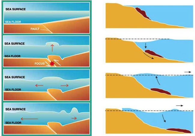
Tsunamis caused by large subduction zone earthquakes are some of the most destructive natural hazards on Earth. In addition to the sudden change in the seafloor caused by the earthquake, if an earthquake occurs close to the trench, it can trigger an underwater landslide in the sediment layers at the trench above the shallow section of the fault. Such landslides cause more water to be displaced and add to the height of the tsunami waves that hit the coastline closest to the location of the landslide. This occurred during the devastating magnitude 9.1 Tohoku-oki earthquake that happened in 2011 offshore Japan. The earthquake ruptured into the shallow portion of the subduction zone by the trench and caused an underwater landslide on the northern edge of the earthquake’s rupture area.
Like Japan, the Cascadia subduction zone offshore the Pacific Northwest has experienced large subduction earthquakes in the past and will experience them in the future. The historical earthquake record for this region shows evidence of large tsunamis and underwater landslides, so it is important to develop accurate tsunami early warning systems for the coastal populations in this region.
Local tsunami warning systems in development for Cascadia are using land-based seismic networks (seismometers and accelerometers) and geodetic networks (GPS) to rapidly estimate the characteristics of earthquakes such as starting location, magnitude, and the amount of motion on the fault. These earthquake characteristics can then be put into a tsunami model which calculates the expected wave height and the time it will take for the wave to reach the coastline. This information is the basis for the early warnings issued to the coastal communities of the Pacific Northwest. However, such warning systems will have a difficult time estimating any additional effects caused by underwater landslides because the landslides would occur close to the trench and far from the early warning network’s instruments.
One way to improve tsunami early warnings is to identify regions along the trench that are more likely to collapse in a landslide. If an earthquake occurs close to one of these regions, the warning of the incoming tsunami could be modified to say that there is the possibility of an underwater landslide and that the people closest to the possible slide area should evacuate to even higher ground.
Right now, there is not a lot of data for the near-trench region offshore Oregon that can be used to identify potential future landslide locations. Our expedition on the R/V Revelle will help fill in some of the gaps. This mission targets a past underwater landslide offshore Oregon. By imaging the structure of the slide, we can learn about the conditions that caused the landslide at that location. After we image this region, we will travel northward and image sections of the deformation zone near the trench that have not experienced a large underwater landslide. We hope to use the information from the landslide to assess the possibility of landslides in these locations. These data will greatly improve tsunami early warnings when the next “really big one” occurs.
— Jessie Saunders is a Ph.D. student at Scripps Institution of Oceanography